Advanced Engineering & Construction executes civil works across Karachi under PEC Licence No. 17347, Category C4/E. Sea-level rise is not an abstract climate topic for Karachi’s coastline. It is a design variable. It affects foundation levels, drainage planning, and material choice on any coastal or low-lying project. Most Karachi contractor websites do not address it at all. Karachi’s coastal data, the design research built on it, and the city’s own drainage failures all deserve a direct look.
What the Data Actually Shows for Karachi's Coast
Karachi's tide gauge records show a long-term mean sea level rise near 1.1 millimetres per year. That figure comes from decades of harbour data. A more recent analysis looked at extreme sea level events using 2007 to 2016 tide gauge data. It found the rate of change had increased to roughly 2.1 millimetres per year. Karachi's coastline does not erode uniformly. Measured shoreline change shows erosion near 2.4 metres per year on the eastern stretch. The southern stretch shows accretion near 8.3 metres per year instead, driven by sediment movement and human land use. In 2015, the National Institute of Oceanography briefed the Senate committee on science and technology. The briefing warned that unchecked coastal erosion trends could threaten Karachi's coastal areas by 2060. That warning describes a worst-case trajectory tied to continued erosion, not a fixed forecast. It still underscores why coastal design decisions made today matter over a multi-decade horizon.
A 2019 study in Nature Communications found land home to 300 million people will face annual coastal flooding by 2050. Researchers used improved elevation modelling to reach that figure, roughly three times higher than earlier estimates. South Asia was flagged among the hardest-hit regions. Bangladesh and India were named specifically, alongside several East and Southeast Asian countries. Pakistan was not named individually in that study. Karachi's own tide gauge and erosion data still place it inside the same regional risk pattern the study describes.
Why Karachi's Risk Isn't Uniform Across the Coastline
Research on Karachi's shoreline found the Clifton and DHA coastal zone stayed relatively stable historically. That stability came largely from less infrastructure and land reclamation than other stretches carried. It is not permanent. Ongoing reclamation and dense coastal development change the shoreline's shape over time. Natural processes had otherwise kept that shoreline in balance. Low-lying creek and deltaic areas near Karachi face a different risk profile entirely. They sit closer to sea level. They also depend more heavily on natural sediment supply from the Indus system to offset erosion.
Land Subsidence Makes the Global Number Worse Locally
Global sea-level rise figures do not capture the full picture for a specific coastline. Local land subsidence adds directly to the relative rate a coastal structure actually experiences. Research on Pakistan's coastal zones has flagged land subsidence in the deltaic area as a real factor here. It could push Karachi's effective sea-level rise rate well above the historical 1.1 millimetre baseline. Subsidence happens when sediment compacts, or when groundwater is withdrawn faster than it recharges. Both conditions are relevant to a rapidly urbanising delta coastline. A project on reclaimed or deltaic land needs a different risk assumption than one on stable bedrock further inland.
The Jakarta Warning: What Groundwater Extraction Does to a Delta City
Jakarta offers a cautionary comparison, not a prediction for Karachi. Indonesia's capital sits on a river delta. It has become one of the fastest-sinking megacities on record. Parts of North Jakarta have subsided by several centimetres in a single year. Researchers trace most of that subsidence to groundwater over-extraction, not sea-level rise itself. Millions of residents without a reliable piped water supply have drawn down the aquifers beneath the city for decades. The added weight of dense construction on soft delta sediment compounds the problem further. Karachi is not Jakarta. Its documented subsidence data does not currently show comparable rates. The underlying mechanism is the same one at work in any delta city. Heavy groundwater reliance, combined with soft sedimentary ground, moves land downward. Climate-driven sea levels move water upward at a far slower pace by comparison. That mechanism is worth watching as Karachi's water demand grows, not dismissing because the city has not reached Jakarta's scale.
Sea-Level Rise Doesn't Act Alone: Karachi's Drainage Problem Compounds It
International coastal resilience research consistently frames flooding as compound risk. Storm surge, rainfall, drainage capacity, and sea level interact rather than acting as separate threats. Karachi already demonstrates that interaction without any help from sea-level rise. The August 2020 floods were triggered by the heaviest single-day rainfall the city had recorded in 92 years. At least 41 people died, in the worst flooding Karachi had seen since 1931. Post-flood assessments found the city's natural drainage channels had been narrowed by construction encroachment at multiple points. These are the nullahs that carry the Lyari and Malir systems toward the sea. One drain near Cantt Station had been reduced from 50 feet wide to 36 feet by construction. Drainage near Qayoomabad had been built over directly. A coastal or low-lying project that ignores local drainage capacity is exposed to this same failure mode. That holds true regardless of what sea-level projections say on their own. A rising sea also reduces the outfall capacity available to move that rainwater away in the first place.
What International Design Research Suggests: Adjustable Flood Elevations
Coastal engineering research in cities like Honolulu's Waikīkī district has moved away from a single fixed flood benchmark. Researchers instead model a range of sea-level-rise scenarios. Buildings get designed with adjustable, sea-level-rise-adjusted flood elevations. Those elevations can be revised later as monitoring data improves. That approach treats coastal design as a living decision, not a one-time calculation locked in at the permit stage. Dutch flood management research offers a related principle. It is often summarised as giving rivers and floodwater more room, not just higher walls. Combining conveyance capacity with elevation strategy, rather than relying on either alone, is where current coastal adaptation research points. Karachi's monsoon drainage limitations make that combined framing directly relevant here, not a borrowed foreign concept.
Foundation and Site Design Considerations for Soft Coastal Ground
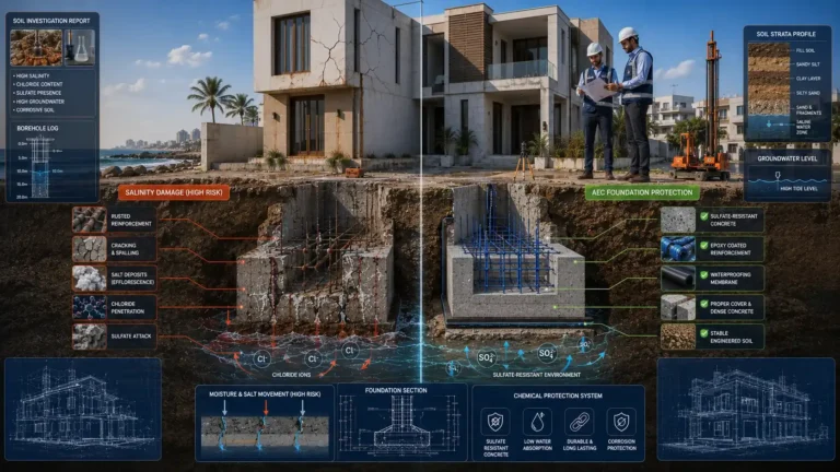
Reclaimed and deltaic ground typically carries lower bearing capacity than stable inland soil. That difference shapes foundation choice before anything else on a coastal project. Shallow spread footings that work well on firmer inland sites can settle unevenly on soft, compressible coastal ground. Pile foundations, driven or bored to a more competent bearing stratum, are the standard response on soft or reclaimed ground. Karachi's coastal geology is no exception to that principle. Soil investigation before design, not after it, determines which approach a specific site actually needs. Skipping that step on a coastal or reclaimed site is one of the more expensive mistakes a project can make. Correcting a foundation problem after construction costs far more than testing the ground before it.
What This Means for a 20 to 30 Year Design Horizon in Karachi
A structure built today on Karachi's coast, or on reclaimed land, will still be standing decades from now. It will still be standing when the higher end of current sea-level-rise projections could materialise. Foundation elevation, ground floor use, and site drainage all carry different weight once that horizon is taken seriously. Ground floor spaces on vulnerable sites can be planned for parking, storage, or utilities instead of habitable space. That is a standard adaptive design move in flood-exposed coastal cities. Site drainage design benefits from accounting for storm surge and heavy monsoon rainfall together. It should also route water toward outfalls that are not already constrained by encroachment elsewhere in the system. Material specification also matters more on a coastal site. Salt-laden air and groundwater accelerate corrosion in reinforcement steel. They also degrade standard coatings faster than inland conditions would.
What Coastal Risk Means for Institutional and Government Projects
Government and institutional clients carry a different risk calculus than a single homeowner. A public building or infrastructure asset must serve for decades under a fixed procurement budget. Later retrofit funding is rarely guaranteed. PWD and PDMA-type projects, and institutional clients such as universities, typically carry larger footprints than a private home. Their service-life expectations run longer too. Coastal or low-lying institutional sites carry compounding exposure. Poor early-stage risk assessment on a government asset is costly to correct later. The same oversight is cheaper to fix on a smaller private project. A procurement process asking for site-specific coastal and drainage data at the design stage protects the asset's decades-long service life.
What a Karachi Property Owner or Developer Can Actually Do Now
A site-specific elevation survey, not a generic city-wide flood map, is the starting point for any coastal or low-lying project. Geotechnical investigation should follow before foundation type is finalised, particularly on reclaimed or deltaic land. Checking a site's proximity to nullahs and existing drainage matters as much as checking its distance from the coastline. Material specification for reinforcement cover, coatings, and finishes should reflect coastal exposure rather than a standard inland default. None of these steps require exotic technology or heavy added cost when built into the design stage from the start. They require treating coastal risk as a design input rather than an afterthought.
Why AEC Treats This as a Design Question, Not a Slogan
Most sustainability or resilience content aimed at the Pakistani construction market repeats global talking points. It rarely connects them to a specific coastline's actual data. Karachi's sea-level trend, its uneven erosion pattern, its subsidence risk, and its documented drainage failures are all measurable, published findings. None of this is speculation. AEC's specialization codes span civil, electrical, and mechanical works under PEC Licence No. 17347. Site-specific risk factors like these inform foundation and drainage decisions on relevant coastal or low-lying projects. A client evaluating a coastal or near-coastal site should ask a contractor what data actually informs that project's design. That question matters more than whether the word resilience appears on the page.
Advanced Engineering & Construction is based at Office 34, Decent Towers, Block 15, Gulistan-e-Johar, Karachi. The company can be reached at +92-320-1176827 or Advancedengineeringc@gmail.com. Full details on AEC's civil, electrical, and mechanical works sit on the company homepage at advancedengineering.com.pk.